Ma Pi Leng Pass Ha Giang Loop tour: Best Viewpoints and Ride Timing
Discover the best viewpoints and ride timing for a Ma Pi Leng Pass Ha Giang Loop tour, including Sky Path, Nho Que River, weather, ride duration and Easy Rider options.
A Ma Pi Leng Pass Ha Giang Loop tour is one of the highlights of any journey through northern Vietnam. The road between Dong Van and Meo Vac combines steep limestone mountains, deep valleys, sharp bends and panoramic views over the Nho Que River. However, experiencing Ma Pi Leng properly depends on more than simply riding through the pass. Timing, visibility, weather and the number of stops all affect the day. With Odyssey, travelers can experience Ma Pi Leng at a more comfortable pace, leaving enough time for viewpoints, short walks and scenic stops rather than treating the pass as another checkpoint.
Best Viewpoints on a Ma Pi Leng Pass Ha Giang Loop Tour
A Ma Pi Leng Pass Ha Giang Loop tour should include more than one quick photo stop.
The landscape changes continuously between Dong Van and Meo Vac, so the best experience usually combines one major viewpoint with smaller roadside stops when conditions are safe.
Ma Pi Leng Pass and Nho Que River on the Ha Giang Loop
Main Ma Pi Leng Pass Viewpoint
The main viewpoint is one of the easiest places to understand the scale of Ma Pi Leng.
From the higher sections of the road, you can see:
Limestone ridges.
Deep valleys.
The Nho Que River.
Mountain roads cutting across the cliffs.
Distant villages.
This stop deserves more than a few minutes.
Allow Around 15–30 Minutes
This usually gives you enough time to:
Walk around.
Take photographs.
Enjoy the view.
Rest before continuing.
If visibility is particularly good, staying longer can be worthwhile.
Check Visibility Before Settling In
Fog and low cloud can hide the river and surrounding cliffs.
Mountain conditions may also change quickly.
If one viewpoint is completely covered, another stop farther along the road may offer better visibility.
Look Beyond the River
The Nho Que River attracts much of the attention, but it is only one part of the landscape.
Also look for:
Road curves.
Cliff formations.
Mountain layers.
Small settlements.
Changes in light.
These elements often make the wider Ma Pi Leng scenery more interesting than a single river photograph.
Ma Pi Leng Sky Path
The Ma Pi Leng Sky Path is suitable for travelers who want to experience the area beyond roadside viewpoints.
Walking part of the route changes the perspective because you leave the main road and move through the landscape at a much slower pace.
Wear Suitable Footwear
Some sections can be:
Steep.
Uneven.
Rocky.
Walking shoes are generally more practical than sandals.
Do Not Rush the Walk
The purpose is not to reach the farthest point as quickly as possible.
Take time to:
Look at the mountain layers.
Stop for photographs.
Rest when needed.
Enjoy the quieter perspective away from the road.
You Do Not Need to Walk the Entire Route
A shorter section can still provide excellent views.
This is particularly useful if you are following a tighter three-day itinerary.
Travelers on a four-day route generally have more flexibility for walking and extended scenic stops.
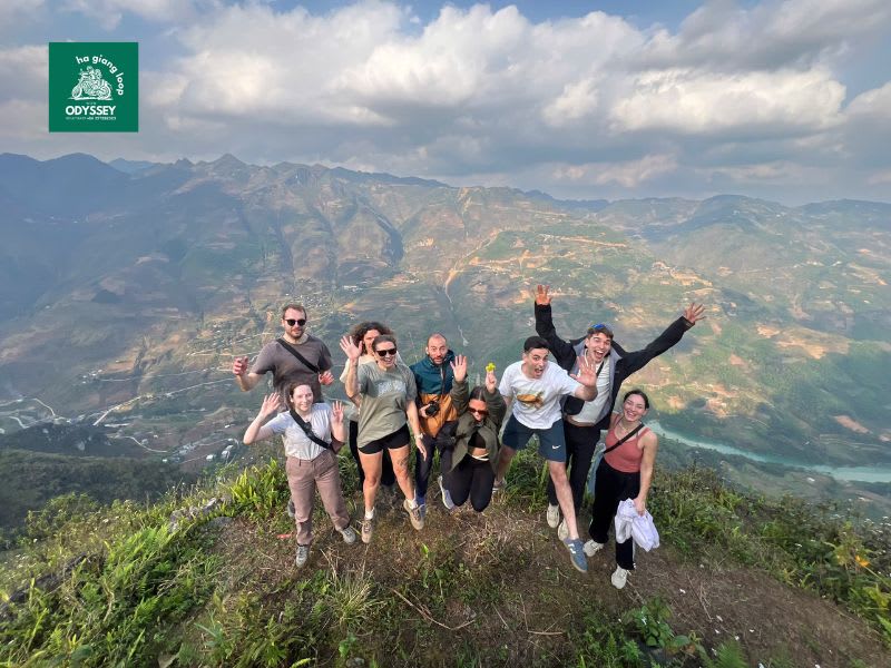
Panoramic viewpoint overlooking Ma Pi Leng Pass
Nho Que River and Tu San Canyon Views
One of the most recognizable views from Ma Pi Leng is the Nho Que River far below the pass.
From the elevated road, the river appears between massive limestone cliffs.
This perspective helps show how deeply the river cuts through the surrounding mountains.
However, viewing the river from the pass is very different from descending toward it for a boat trip.
Viewing From the Pass
This requires relatively little additional time.
You can include it as part of the normal Ma Pi Leng ride.
Going Down to the River
A boat trip requires considerably more time because you may need to:
Leave the main road.
Travel toward the river.
Reach the boat area.
Wait for departure.
Complete the boat trip.
Return to the main route.
If the Nho Que River is one of your priorities, treat it as a separate activity rather than another quick viewpoint.
You can explore Odyssey’s Ha Giang Loop destinations to see how Ma Pi Leng and the Nho Que area fit into the wider route.
Smaller Roadside Stops Between Dong Van and Meo Vac
Some of the best views are not located at official viewpoints.
Along the road between Dong Van and Meo Vac, smaller openings can reveal:
Valleys.
Villages.
Sections of winding road.
Mountain ridges.
Different angles of the canyon.
These stops can make a Ma Pi Leng day feel more personal and less rushed.
However, safety must come first.
The road includes:
Narrow sections.
Sharp bends.
Steep edges.
Passing traffic.
Only stop where there is enough space to move completely away from the traffic lane.
A local guide or Easy Rider can also help identify suitable stopping points that may not appear clearly on standard maps.
Traveler walking the Ma Pi Leng Sky Path
Best Time of Day for Ma Pi Leng Pass
For many travelers, the first half of the day is a practical time to ride Ma Pi Leng.
You still have plenty of daylight and enough flexibility for additional stops.
Morning works particularly well when starting from Dong Van.
Early Morning
Advantages:
Cooler temperatures.
Quieter atmosphere.
Softer light in some conditions.
The main drawback is fog.
Cloud can sit low in the valley and temporarily hide the major views.
Mid-Morning
Around 8:00–10:30 can work well for many itineraries.
You still have enough time for:
Scenic viewpoints.
Photography.
Short walks.
Optional detours.
Visibility ultimately matters more than the exact hour.
Midday
The scenery remains dramatic, but stronger sunlight can make photography harsher.
Midday can still be practical when:
Morning fog has cleared.
Visibility has improved.
Your route requires a later crossing.
Late Afternoon
Late-afternoon light can be attractive.
However, avoid delaying the pass if you still have a long ride toward Meo Vac, Du Gia or another overnight stop.
Mountain roads are better experienced with enough daylight remaining.
How Long Should You Spend at Ma Pi Leng Pass?
The distance between Dong Van and Meo Vac may appear short on a map.
But riding time alone does not represent the full experience.
For a standard crossing with one or two main viewpoints, allow roughly 1.5–2 hours.
You will need more time if you add other activities.
Several Photography Stops
Every stop adds time.
If conditions are particularly clear, it is easy to spend much longer than expected photographing the pass.
Ma Pi Leng Sky Path
Walking should be treated as its own activity.
Do not include it inside the normal riding-time estimate.
Nho Que River Boat Trip
A river visit can take several hours once access, transfers, waiting and the boat experience are included.
Coffee or Food Stops
A break can make the riding day more comfortable.
This is especially useful if Ma Pi Leng forms only one part of a longer route.
Nho Que River and Tu San Canyon below Ma Pi Leng Pass
3-Day vs 4-Day Itinerary at Ma Pi Leng
The number of days available changes how much time you can comfortably spend around the pass.
On a 3-Day Ha Giang Loop
Time management becomes more important.
You may need to prioritize:
The main viewpoint.
Nho Que views.
One or two additional stops.
Adding the Sky Path, a long boat trip and multiple detours can make the day too compressed.
On a 4-Day Ha Giang Loop
There is usually more flexibility.
The extra time can be used for:
Longer viewpoints.
Photography.
Walking.
Nho Que River.
More relaxed meal breaks.
The advantage is not simply covering more distance.
It is having more time around the places already worth seeing.
Weather and Visibility on Ma Pi Leng Pass
Weather has a major influence on the Ma Pi Leng experience.
Even a carefully planned itinerary may need to change when mountain conditions shift.
Fog
Thick fog can hide:
Nho Que River.
Canyon walls.
Distant mountains.
Sometimes visibility improves quickly.
Other times, cloud remains for much of the day.
Rain
Wet roads require:
Slower speed.
More careful braking.
Greater stopping distance.
More controlled cornering.
Photography stops can also become less practical during heavy rain.
Strong Sunshine
Clear weather improves long-distance visibility.
However, exposed viewpoints can feel much hotter around midday.
Cool Temperatures
Higher elevations can feel noticeably colder than valleys.
This is particularly noticeable:
Early in the morning.
During winter.
When riding at speed.
Travelers should prepare for changing conditions rather than expecting Ma Pi Leng to look exactly like online photographs.
Easy Rider or Self-Ride at Ma Pi Leng?
Your riding format changes how you experience the pass.
Self-Ride
Experienced riders may enjoy controlling their own motorcycle.
However, Ma Pi Leng requires continuous attention.
The road includes:
Sharp bends.
Elevation changes.
Traffic.
Narrow sections.
Changing road conditions.
A self-rider cannot spend much time looking away from the road while moving.
Self-riding is better suited to travelers who already have suitable mountain-riding experience and appropriate documentation.
Morning ride across Ma Pi Leng Pass
Easy Rider
With an Easy Rider, you travel as the passenger while an experienced local rider controls the motorcycle.
This allows you to spend more attention on:
Mountain scenery.
Nho Que River.
Photography.
Roadside views.
You also avoid responsibility for:
Navigation.
Braking.
Cornering.
Motorcycle control.
For many first-time visitors, this can make Ma Pi Leng feel considerably more relaxed.
Guided Self-Ride
Guided self-riding provides another option.
You control your own motorcycle while following a guide who helps with:
Navigation.
Viewpoints.
Route planning.
Daily logistics.
You still need suitable riding skills because the guide does not control the bike for you.
Photography Tips for Ma Pi Leng Pass
Ma Pi Leng is highly photogenic, but the best photograph does not always come from the busiest viewpoint.
Include the Road
The winding mountain road helps show the scale and character of the pass.
Use People or Motorcycles for Scale
The mountains are enormous.
Adding a rider, traveler or motorcycle to the frame helps communicate that scale.
Watch the Clouds
Moving cloud can dramatically change the scene.
Sometimes waiting 10–15 minutes creates a completely different view.
Do Not Ignore Fog
Clear weather is not the only good photography condition.
Fog can create:
Mountain layers.
Atmospheric roads.
Dramatic silhouettes.
Look for Different Angles
Do not take every photograph from exactly the same official viewpoint.
Smaller safe stops can reveal very different compositions.
What Should You Bring for Ma Pi Leng?
Even on a relatively short riding day, basic preparation improves comfort.
Consider bringing:
Light jacket.
Rain protection.
Drinking water.
Sun protection.
Comfortable walking shoes if using the Sky Path.
Small camera or phone protection.
Waterproof bag or cover in wet weather.
Weather can change quickly at higher elevations.
Fog and changing weather around Ma Pi Leng Pass
Do Not Rush the Best Part of the Loop
A Ma Pi Leng Pass Ha Giang Loop tour should not feel like a short transfer between Dong Van and Meo Vac.
The pass deserves enough time for:
The main viewpoint.
Smaller roadside stops.
Nho Que River views.
Photography.
The Sky Path when your schedule allows.
For many travelers, riding during the morning or earlier part of the day provides a practical balance between daylight and flexible stopping time.
However, visibility and road conditions matter more than arriving at one exact hour.
The best approach is to leave enough room in your itinerary for Ma Pi Leng to become part of the journey rather than another place you need to complete.
With Odyssey, travelers can experience the pass within a Ha Giang journey designed around manageable riding time, local knowledge and enough time to stop where the landscape deserves more than a quick photograph.
Experience the Nho Que river boat Ha Giang loop tour through Tu San Canyon. Complete guide to ticket prices, boat wharfs, motorbiking routes, and tips!
Visit Lung Cu Flag Tower Ha Giang Loop: Vietnam’s northernmost point with panoramic views. Get essential travel tips, motorbiking routes, and ticket info!
Discover the best time to do the Ha Giang Loop with a month-by-month weather guide covering temperatures, rain, rice season, flowers and ideal riding conditions.